Lyme Disease Map
Did you just find a tick on yourself or a loved one? TickCheck can test your tick and determine whether it carries the bacteria that transmit Lyme disease and other tick-borne infections.
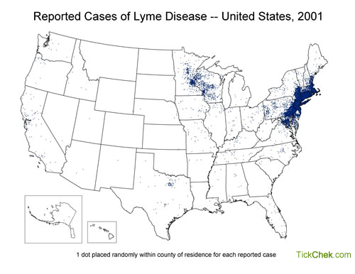
This animated map shows the spread of Lyme disease (as reported to the CDC) between 2001 and 2011. The data is plotted with a single blue dot representing each reported case placed randomly within the victim's county of residence.
As you can see, Lyme disease has been growing steadily in the northeast, upper midwest, and western regions of the United States over the last decade. According to the CDC, Lyme disease is the 7th most commonly reported Notifiable Disease in the United States.
Research has shown that the vast majority of Lyme disease infections are concentrated in thirteen states - Connecticut, Delaware, Maine, Maryland, Massachusetts, Minnesota, New Hampshire, New Jersey, New York, Pennsylvania, Vermont, Virginia, and Wisconsin.
In recent years, however,more and more confirmed cases of Lyme disease have been reported outside of these highest-risk states as the deer tick continues to spread across the country.
Data courtesy of the Centers for Disease Control and Prevention. Map represents victim's county of residence, not county of exposure.
Connect with TickCheck on Facebook & Instagram for the latest tick news and tips!